PGFA Highlight: New methods for identifying and addressing inequality in Brazil

Luc Anselin, the Stein-Freiler Distinguished Service Professor of Sociology at the University of Chicago, specializes in spatial data science and econometrics. He directs the Center for Spatial Data Science, which develops and disseminates state-of-the-art methods for geospatial analysis, including open spatial computational tools for research education, such as GeoDa and PySAL's spatial econometrics package spreg.
Since 2010, Anselin has collaborated with Professor Pedro Amaral from Universidade Federal de Minas Gerais (Cedeplar/UFMG) on projects addressing regional disparities and spatial economic models in Brazil related to topics in healthcare, property tax estimation, and housing market research. Since 2019, UChicago Global has contributed to this work by funding mobility for the PIs and a local research assistant to support data collection.
Accessibility to primary health services
Their first project supported by UChicago Global focused on spatial disparities that led to unequal healthcare access in Brazil, where rural and less developed regions are historically underserved. The Brazilian Ministry of Health created the More Doctors Program (MDP) in 2013 to provide physician coverage in regions and cities that are vulnerable and lack a qualified workforce. The program was halted with the election of President Jair Bolsonaro in 2019, and the exodus of doctors was concentrated in underserved communities. By using small area spatial data–a common approach in the US, but less common in Brazil–the investigators were able to evaluate changes in preventable hospitalizations and their relationship with accessibility, income, and other socioeconomic aspects during this transitional period. The study identified the areas in Brazil with coverage gaps and their spatial concentration, highlighting localities that should be prioritized for investment. The research also led to a software contribution to PySAL/spreg, a Python library for spatial analytical methods on which Anselin and Amaral have worked together for years.
Estimation of property taxes
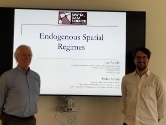
Anselin and Amaral next continued their collaboration by focusing on the estimation of property taxes in Brazil. Currently, there is no federal legislation in Brazil that determines how to establish the market value of a property; rather, municipal districts provide criteria and parameters to estimate the generic value plan (GVP). This leads to wide variation in the methods of estimation across municipalities. This project proposed advancing the estimation of mass appraisal models using spatial regimes regressions, theory contributing to reducing regional inequalities in municipal planning in Brazil, as well as developing tutorials and tools to make the method accessible to practitioners.
Due to data availability, the complexity of estimation methods, and financial constraints on purchasing specialized software, the different methods and knowledge required to estimate a generic value plan (GVP) have led to regional inequalities in municipal planning in Brazil. Professor Anselin’s project aimed to leverage spatial regime regression to enhance mass appraisal models. This approach facilitates the scalable estimation of endogenous regimes models, including housing models and generic value plans, which contributes to the reduction of regional inequalities in municipal planning in Brazil and beyond.
Documentation and full implementation of the methods was made available as free and open-source additions to PySAL/spreg, a library downloaded over 790,000 times worldwide. This will be continued and extended as part of an NSF funded project to establish an Open Source Ecosystem for Spatial Data Science.
In the future, Anselin and Amaral plan to continue their partnership by focusing on the development of new estimation tools for endogenous spatial regimes to better tackle spatial heterogeneity, including enhancing their models with AI-based methods to assist researchers in their specification search strategies and further applying these advanced tools to a research project on housing markets in Brazil.

